
La Possession topographic map
Interactive map
Click on the map to display elevation.
About this map
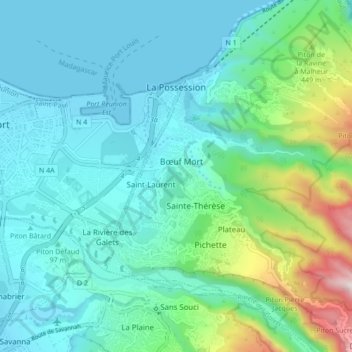
Name: La Possession topographic map, elevation, terrain.
Location: La Possession, Saint-Paul, Reunião, 9719, França (-20.98713 55.29618 -20.90713 55.37618)
Average elevation: 719 ft
Minimum elevation: -3 ft
Maximum elevation: 3,698 ft
Other topographic maps
Click on a map to view its topography, its elevation and its terrain.
Cayenne
França > Reunião > La Possession > Cayenne
Cayenne, La Possession, Saint-Paul, Reunião, 97419, França
Average elevation: 3,005 ft