
Make a donation
Gear up for your next adventure:
As an Amazon Associate, this site earns from qualifying purchases at no extra cost to you.
LaGrange topographic map
Click on the map to display elevation.
Make a donation
Gear up for your next adventure:
As an Amazon Associate, this site earns from qualifying purchases at no extra cost to you.
LaGrange
LaGrange is named after the country estate near Paris of the wife of the Marquis de La Fayette. When La Fayette, a Revolutionary War hero, visited Georgia in 1825 on a national tour, he remarked on the similarity of local topography to his wife's property.
Make a donation
Gear up for your next adventure:
As an Amazon Associate, this site earns from qualifying purchases at no extra cost to you.
About this map
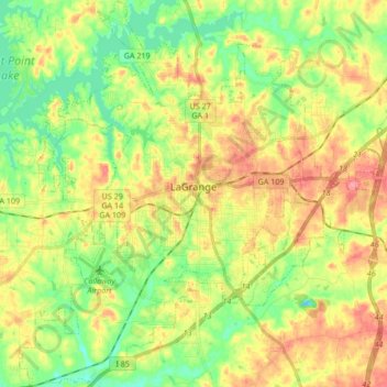
Name: LaGrange topographic map, elevation, terrain.
Location: LaGrange, Troup County, Georgia, United States (32.96588 -85.10746 33.10750 -84.94995)
Average elevation: 722 ft
Minimum elevation: 594 ft
Maximum elevation: 873 ft
Troup County trails, hiking, mountain biking, running and outdoor activities
Make a donation
Gear up for your next adventure:
As an Amazon Associate, this site earns from qualifying purchases at no extra cost to you.
Other topographic maps
Click on a map to view its topography, its elevation and its terrain.
Make a donation
Gear up for your next adventure:
As an Amazon Associate, this site earns from qualifying purchases at no extra cost to you.