
Canela topographic map
Click on the map to display elevation.
Canela
It is located at a latitude of 29º21'56" south and a longitude of 50º48'56" west, at an altitude of 837 meters. Its estimated population in 2018 was 44,489 inhabitants, according to the Brazilian Institute of Geography and Statistics. It has an area of 252.91 km², representing 0.0947 percent of the territory of Rio Grande do Sul.
About this map
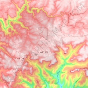
Name: Canela topographic map, elevation, terrain.
Average elevation: 2,198 ft
Minimum elevation: 302 ft
Maximum elevation: 2,966 ft
Other topographic maps
Click on a map to view its topography, its elevation and its terrain.
Porto Alegre
Brazil > Rio Grande do Sul > Metropolitan Region of Porto Alegre > Porto Alegre
Porto Alegre has a long coastline on the Guaíba Lake, and its topography is punctuated by 40 hills. In the lake, a vast body of water, a maze of islands facing the city creates an archipelago where a unique ecosystem gives shelter to abundant wildlife. The city area concentrates 28% of the native flora of Rio…
Average elevation: 89 ft
Pelotas
Brazil > Rio Grande do Sul > Aglomeração Urbana do Sul > Pelotas
As it is situated on a plain near the ocean, the urban area lies on a low elevation, being, on average, 7 meters (23 ft) above sea level. The interior of the municipality is on a plateau called Serras de Sudeste (Southeastern Mountain Ranges). Consequently, the altitude in Pelotas' rural area reaches 429…
Average elevation: 59 ft
Estrada Carlos Dreyer
Brazil > Rio Grande do Sul > Metropolitan Region of Porto Alegre > Igrejinha
Average elevation: 2,041 ft
Fazenda Capão do Capim
Brazil > Rio Grande do Sul > São Francisco de Paula
Average elevation: 3,159 ft