
Make a donation
Gear up for your next adventure:
As an Amazon Associate, this site earns from qualifying purchases at no extra cost to you.
Marum topographic map
Click on the map to display elevation.
Make a donation
Gear up for your next adventure:
As an Amazon Associate, this site earns from qualifying purchases at no extra cost to you.
Marum
Dutch Topographic map of the municipality of Marum, June 2015
Make a donation
Gear up for your next adventure:
As an Amazon Associate, this site earns from qualifying purchases at no extra cost to you.
About this map
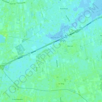
Name: Marum topographic map, elevation, terrain.
Location: Marum, Westerkwartier, Groningen, Netherlands (53.11338 6.17568 53.16826 6.29283)
Average elevation: 10 ft
Minimum elevation: -7 ft
Maximum elevation: 26 ft
Make a donation
Gear up for your next adventure:
As an Amazon Associate, this site earns from qualifying purchases at no extra cost to you.
Other topographic maps
Click on a map to view its topography, its elevation and its terrain.
Make a donation
Gear up for your next adventure:
As an Amazon Associate, this site earns from qualifying purchases at no extra cost to you.