
Broadway topographic map
Click on the map to display elevation.
About this map
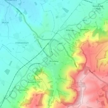
Name: Broadway topographic map, elevation, terrain.
Location: Broadway, Wychavon, Worcestershire, England, United Kingdom (52.00677 -1.89990 52.07262 -1.82503)
Average elevation: 417 ft
Minimum elevation: 118 ft
Maximum elevation: 1,063 ft
Other topographic maps
Click on a map to view its topography, its elevation and its terrain.
Atch Lench
United Kingdom > England > Worcestershire > Wychavon > Church Lench
Average elevation: 262 ft
Earls Common
United Kingdom > England > Worcestershire > Wychavon > Himbleton
Average elevation: 167 ft
Stock Green
United Kingdom > England > Worcestershire > Wychavon > Inkberrow
Average elevation: 180 ft
Badsey Lane Nature Reserve
United Kingdom > England > Worcestershire > Wychavon > Evesham
Average elevation: 121 ft