
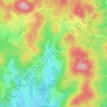
Les Chaussades topographic map
Interactive map
Click on the map to display elevation.
About this map
Name: Les Chaussades topographic map, elevation, terrain.
Average elevation: 2,293 ft
Minimum elevation: 1,946 ft
Maximum elevation: 2,703 ft
Other topographic maps
Click on a map to view its topography, its elevation and its terrain.
Commerly
France > Nouvelle-Aquitaine > Corrèze > Saint-Yrieix-le-Déjalat
Commerly, Saint-Yrieix-le-Déjalat, Ussel, Corrèze, Nouvelle-Aquitaine, France métropolitaine, 19300, France
Average elevation: 2,484 ft
Laborde
France > Nouvelle-Aquitaine > Corrèze > Saint-Yrieix-le-Déjalat
Laborde, Saint-Yrieix-le-Déjalat, Ussel, Corrèze, Nouvelle-Aquitaine, France métropolitaine, 19300, France
Average elevation: 2,251 ft
Le Monteil
France > Nouvelle-Aquitaine > Corrèze > Saint-Yrieix-le-Déjalat
Le Monteil, Saint-Yrieix-le-Déjalat, Ussel, Corrèze, Nouvelle-Aquitaine, France métropolitaine, 19300, France
Average elevation: 2,385 ft