
San Feliz de las Lavanderas topographic map
Interactive map
Click on the map to display elevation.
About this map
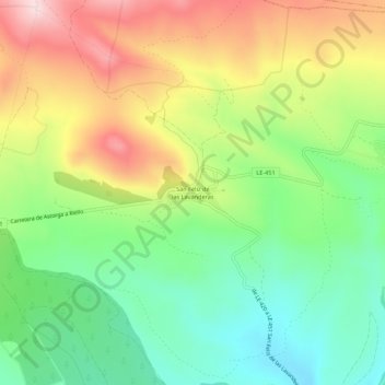
Name: San Feliz de las Lavanderas topographic map, elevation, terrain.
Average elevation: 3,825 ft
Minimum elevation: 3,346 ft
Maximum elevation: 4,491 ft
Other topographic maps
Click on a map to view its topography, its elevation and its terrain.
Riofrío
España > Castilla y León > Quintana del Castillo > Riofrío
Riofrío, Quintana del Castillo, León, Castilla y León, 24285, España
Average elevation: 3,219 ft
Escuredo
España > Castilla y León > Quintana del Castillo > Escuredo
Escuredo, Quintana del Castillo, Tierra de Astorga, León, Castilla y León, 24397, España
Average elevation: 3,776 ft