
74427 topographic map
Interactive map
Click on the map to display elevation.
About this map
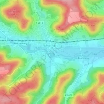
Name: 74427 topographic map, elevation, terrain.
Average elevation: 1,299 ft
Minimum elevation: 1,106 ft
Maximum elevation: 1,578 ft
Other topographic maps
Click on a map to view its topography, its elevation and its terrain.
Kronmühle
Deutschland > Baden-Württemberg > Landkreis Schwäbisch Hall > Fichtenberg > Kronmühle
Kronmühle, Fichtenberg, Verwaltungsverband Limpurger Land, Landkreis Schwäbisch Hall, Baden-Württemberg, 74427, Deutschland
Average elevation: 1,332 ft