
San Rafael de Palo Alzado topographic map
Interactive map
Click on the map to display elevation.
About this map
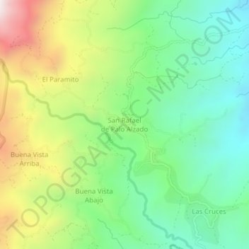
Name: San Rafael de Palo Alzado topographic map, elevation, terrain.
Average elevation: 3,629 ft
Minimum elevation: 2,336 ft
Maximum elevation: 5,909 ft
Other topographic maps
Click on a map to view its topography, its elevation and its terrain.
Biscucuy
Venezuela > Estado Portuguesa > Municipio Sucre
Biscucuy, Parroquia Sucre, Municipio Sucre, Estado Portuguesa, Venezuela
Average elevation: 2,448 ft
Parroquia San Rafael de Palo Alzado
Venezuela > Estado Portuguesa > Municipio Sucre
Parroquia San Rafael de Palo Alzado, Municipio Sucre, Estado Portuguesa, Venezuela
Average elevation: 3,934 ft