Geolocate

园山 topographic map

Interactive map

Click on the map to display elevation.

About this map

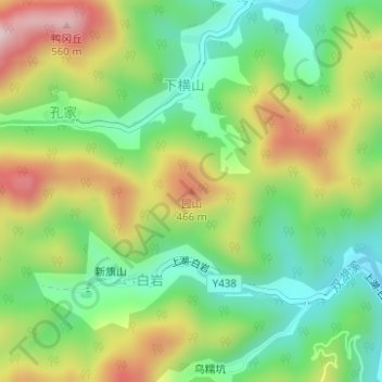
Name: 园山 topographic map, elevation, terrain.

Location: 园山, 宁波市, 浙江省, 中国 (29.41656 121.27975 29.41666 121.27985)

Average elevation: 1,017 ft

Minimum elevation: 499 ft

Maximum elevation: 1,781 ft

Other topographic maps

Click on a map to view its topography, its elevation and its terrain.

火炉山

中国 > 浙江省 > 宁波市

火炉山, 宁波市, 浙江省, 中国

Average elevation: 131 ft

奉化江

中国 > 浙江省 > 宁波市

奉化江, 宁波市, 浙江省, 中国

Average elevation: 16 ft

青虎湾岗

中国 > 浙江省 > 宁波市

青虎湾岗, 宁波市, 浙江省, 中国

Average elevation: 2,365 ft

石浦镇

中国 > 浙江省 > 宁波市

石浦镇, 宁波市, 浙江省, 315731, 中国

Average elevation: 174 ft

东山

中国 > 浙江省 > 宁波市

东山, 宁波市, 浙江省, 中国

Average elevation: 299 ft

庙岭

中国 > 浙江省 > 宁波市

庙岭, 宁波市, 浙江省, 中国

Average elevation: 141 ft

西尖

中国 > 浙江省 > 宁波市

西尖, 宁波市, 浙江省, 中国

Average elevation: 2,375 ft

鄞江镇

中国 > 浙江省 > 宁波市

鄞江镇, 海曙区, 宁波市, 浙江省, 中国

Average elevation: 243 ft