
Villeneuve topographic map
Interactive map
Click on the map to display elevation.
About this map
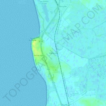
Name: Villeneuve topographic map, elevation, terrain.
Average elevation: 7 ft
Minimum elevation: -3 ft
Maximum elevation: 52 ft
Other topographic maps
Click on a map to view its topography, its elevation and its terrain.
La Cabane des Sables
France > Nouvelle-Aquitaine > Charente-Maritime > Yves
La Cabane des Sables, Yves, La Rochelle, Charente-Maritime, Nouvelle-Aquitaine, France métropolitaine, 17340, France
Average elevation: 7 ft
Les Trois Canons
France > Nouvelle-Aquitaine > Charente-Maritime > Yves
Les Trois Canons, Yves, La Rochelle, Charente-Maritime, Nouvelle-Aquitaine, France métropolitaine, 17340, France
Average elevation: 10 ft