
Les Pommeraies topographic map
Interactive map
Click on the map to display elevation.
About this map
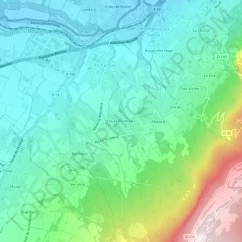
Name: Les Pommeraies topographic map, elevation, terrain.
Average elevation: 2,247 ft
Minimum elevation: 1,526 ft
Maximum elevation: 4,406 ft
Other topographic maps
Click on a map to view its topography, its elevation and its terrain.
Le Salève
France > Auvergne-Rhône-Alpes > Haute-Savoie > Archamps
Le Salève, Archamps, Saint-Julien-en-Genevois, Haute-Savoie, Auvergne-Rhône-Alpes, France métropolitaine, 74160, France
Average elevation: 2,792 ft