
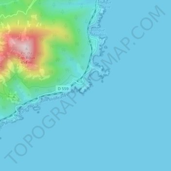
Pointe de l’Observatoire topographic map
Interactive map
Click on the map to display elevation.
About this map
Name: Pointe de l’Observatoire topographic map, elevation, terrain.
Average elevation: 171 ft
Minimum elevation: 0 ft
Maximum elevation: 1,440 ft
Other topographic maps
Click on a map to view its topography, its elevation and its terrain.
Anthéor
France > Provence-Alpes-Côte d'Azur > Var > Saint-Raphaël > Anthéor
Anthéor, Saint-Raphaël, Draguignan, Var, Provence-Alpes-Côte d'Azur, France métropolitaine, 83530, France
Average elevation: 141 ft