
Villacadima topographic map
Interactive map
Click on the map to display elevation.
About this map
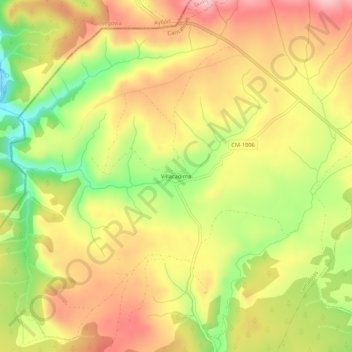
Name: Villacadima topographic map, elevation, terrain.
Average elevation: 4,511 ft
Minimum elevation: 4,147 ft
Maximum elevation: 4,800 ft
Other topographic maps
Click on a map to view its topography, its elevation and its terrain.
Loma de Calamorro
España > Castilla-La Mancha > Cantalojas
Loma de Calamorro, Cantalojas, Guadalajara, Castilla-La Mancha, España
Average elevation: 5,486 ft
Parque Natural Hayedo Tejera Negra
España > Castilla-La Mancha > Cantalojas
Parque Natural Hayedo Tejera Negra, Senda del Robledal, Cantalojas, Guadalajara, Castilla-La Mancha, 19274, España
Average elevation: 4,541 ft