
Quorn topographic map
Interactive map
Click on the map to display elevation.
About this map
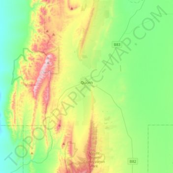
Name: Quorn topographic map, elevation, terrain.
Average elevation: 1,020 ft
Minimum elevation: 236 ft
Maximum elevation: 2,736 ft
Other topographic maps
Click on a map to view its topography, its elevation and its terrain.
Hawker
Australia > South Australia > The Flinders Ranges Council
Hawker, The Flinders Ranges Council, South Australia, 5434, Australia
Average elevation: 1,135 ft
Hawker
Australia > South Australia > The Flinders Ranges Council > Hawker
Hawker, The Flinders Ranges Council, South Australia, 5434, Australia
Average elevation: 1,079 ft
Quorn
Australia > South Australia > The Flinders Ranges Council > Quorn
Quorn, The Flinders Ranges Council, South Australia, 5433, Australia
Average elevation: 1,037 ft