
Mountain Zebra National Park topographic map
Interactive map
Click on the map to display elevation.
About this map
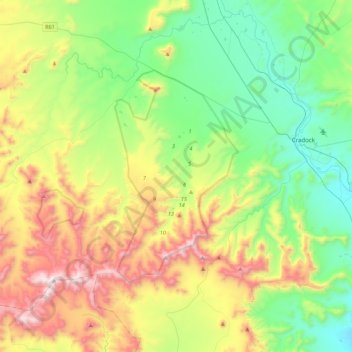
Name: Mountain Zebra National Park topographic map, elevation, terrain.
Average elevation: 4,035 ft
Minimum elevation: 2,726 ft
Maximum elevation: 6,598 ft
Other topographic maps
Click on a map to view its topography, its elevation and its terrain.
Compassberg
RSA > Eastern Cape > Inxuba Yethemba Local Municipality
Compassberg, Inxuba Yethemba Local Municipality, Chris Hani District Municipality, Eastern Cape, RSA
Average elevation: 6,617 ft