
Sierra Morena topographic map
Interactive map
Click on the map to display elevation.
About this map
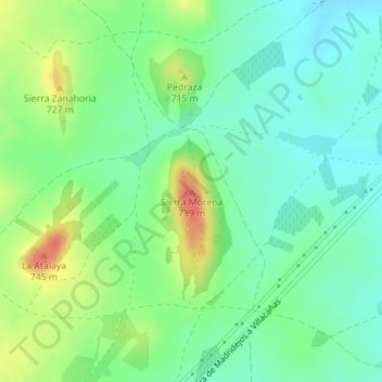
Name: Sierra Morena topographic map, elevation, terrain.
Location: Sierra Morena, Villacañas, Toledo, Castilla-La Mancha, España (39.56029 -3.42609 39.56039 -3.42599)
Average elevation: 2,297 ft
Minimum elevation: 2,228 ft
Maximum elevation: 2,418 ft
Other topographic maps
Click on a map to view its topography, its elevation and its terrain.
Batanejos
España > Castilla-La Mancha > Villacañas
Batanejos, Villacañas, Castilla-La Mancha, España
Average elevation: 2,175 ft