
Eda Glasbruk topographic map
Interactive map
Click on the map to display elevation.
About this map
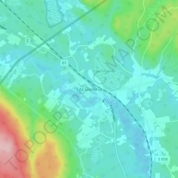
Name: Eda Glasbruk topographic map, elevation, terrain.
Location: Eda Glasbruk, Eda kommun, Värmland County, 673 92, Sweden (59.90134 12.24338 59.94134 12.28338)
Average elevation: 492 ft
Minimum elevation: 371 ft
Maximum elevation: 961 ft
Other topographic maps
Click on a map to view its topography, its elevation and its terrain.
Abborrtjärnsberg
Abborrtjärnsberg, Nyskoga distrikt, Torsby kommun, Värmland County, Sweden
Average elevation: 1,496 ft
Flan
Flan, Nystugan, Eda kommun, Värmland County, Sweden
Average elevation: 509 ft