
Pettenbach topographic map
Interactive map
Click on the map to display elevation.
About this map
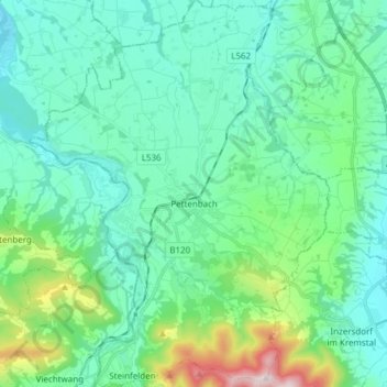
Name: Pettenbach topographic map, elevation, terrain.
Location: Pettenbach, Bezirk Kirchdorf, 4643, Österreich (47.91308 13.95130 48.01491 14.06956)
Average elevation: 1,699 ft
Minimum elevation: 1,280 ft
Maximum elevation: 3,474 ft
Der Hauptort Pettenbach liegt auf 486 m ü. A. Höhe im Traunviertel. Das Gemeindegebiet erstreckt sich vom Pernecker Kogel (1080 m ü. A. m) im Süden bis nach Ried im Traunkreis im Norden. Die Ausdehnung beträgt von Nord nach Süd 8,8 km und von West nach Ost 11,3 km. Die Gesamtfläche beträgt 54,8 km², 15,7 % der Fläche sind bewaldet und 73,7 % der Fläche sind landwirtschaftlich genutzt.
Other topographic maps
Click on a map to view its topography, its elevation and its terrain.
Wartberg an der Krems
Wartberg an der Krems, Bezirk Kirchdorf, 4552, Österreich
Average elevation: 1,516 ft
Edlbach
Edlbach, Bezirk Kirchdorf, 4580, Österreich
Average elevation: 2,215 ft
Spital am Pyhrn
Spital am Pyhrn, Bezirk Kirchdorf, 4582, Österreich
Average elevation: 3,629 ft
Windischgarsten
Windischgarsten, Bezirk Kirchdorf, 4580, Österreich
Average elevation: 2,165 ft
Großer Priel
Österreich > Bezirk Kirchdorf > Hinterstoder
Großer Priel, Hinterstoder, Bezirk Kirchdorf, 4573, Österreich
Average elevation: 6,296 ft
Steinbach an der Steyr
Steinbach an der Steyr, Bezirk Kirchdorf, 4596, Österreich
Average elevation: 1,781 ft