
Chichagof Island topographic map
Interactive map
Click on the map to display elevation.
About this map
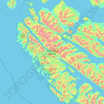
Name: Chichagof Island topographic map, elevation, terrain.
Location: Chichagof Island, Sitka, Alaska, VS (57.36791 -136.44771 58.28798 -134.82777)
Average elevation: 531 ft
Minimum elevation: -23 ft
Maximum elevation: 3,711 ft
Other topographic maps
Click on a map to view its topography, its elevation and its terrain.
Kobuk Valley National Park
Kobuk Valley National Park, Northwest Arctic, Alaska, VS
Average elevation: 1,086 ft
Gates of the Arctic
Gates of the Arctic, Unorganized Borough, Alaska, VS
Average elevation: 2,175 ft
Glacier Bay National Park
Glacier Bay National Park, Hoonah-Angoon, Alaska, VS
Average elevation: 1,824 ft