Geolocate

Idstein topographic map

Click on the map to display elevation.

About this map
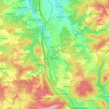
Name: Idstein topographic map, elevation, terrain.

Location: Idstein, Rheingau-Taunus-Kreis, Hesse, 65510, Germany (50.17229 8.20191 50.27871 8.40596)

Average elevation: 1,161 ft

Minimum elevation: 640 ft

Maximum elevation: 1,929 ft

Other topographic maps

Click on a map to view its topography, its elevation and its terrain.

Kalte Herberge

Germany > Hesse > Rheingau-Taunus-Kreis > Hallgarten

Average elevation: 1,699 ft

Dickschied

Germany > Hesse > Rheingau-Taunus-Kreis

Average elevation: 1,175 ft

Hohe Wurzel

Germany > Hesse > Rheingau-Taunus-Kreis > Taunusstein

Average elevation: 1,670 ft

Gear up for your next adventure:

🪶LED Camping Lantern - Bright lantern for camp lighting
🛌Ultralight Sleeping Bags - Compact down bags for cold nights in the wilderness
🧯Portable Fire Pit - Compact fire pit for camping spots
📷Action Cameras - Rugged cameras to document your journeys across rugged terrain
🧦Merino Wool Socks - Moisture-wicking, blister-preventing socks for long treks

As an Amazon Associate, this site earns from qualifying purchases at no extra cost to you.