
Pico Zapatero topographic map
Interactive map
Click on the map to display elevation.
About this map
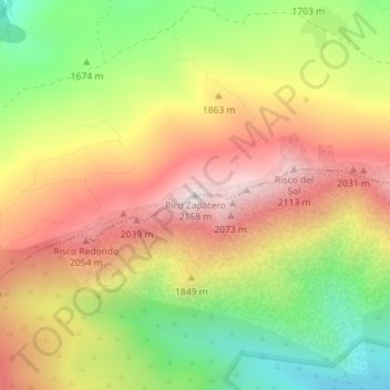
Name: Pico Zapatero topographic map, elevation, terrain.
Location: Pico Zapatero, Sotalbo, Ávila, Castilla y León, España (40.49210 -4.87030 40.49220 -4.87020)
Average elevation: 5,846 ft
Minimum elevation: 4,606 ft
Maximum elevation: 7,005 ft
Other topographic maps
Click on a map to view its topography, its elevation and its terrain.
El Zujar
España > Castilla y León > Sotalbo
El Zujar, Sotalbo, Ávila, Castilla y León, España
Average elevation: 3,635 ft
Las Majadillas
España > Castilla y León > Sotalbo
Las Majadillas, Sotalbo, Ávila, Castilla y León, España
Average elevation: 5,561 ft