
Wellpark topographic map
Interactive map
Click on the map to display elevation.
About this map
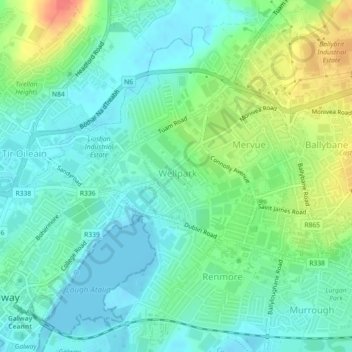
Name: Wellpark topographic map, elevation, terrain.
Location: Wellpark, Galway City, County Galway, Connacht, Ireland (53.27837 -9.03804 53.28897 -9.01661)
Average elevation: 56 ft
Minimum elevation: -3 ft
Maximum elevation: 187 ft
Other topographic maps
Click on a map to view its topography, its elevation and its terrain.
River Corrib
Ireland > Galway City > Galway City
River Corrib, Galway City, County Galway, Connacht, H91 E1NY, Ireland
Average elevation: 23 ft
Parkmore
Ireland > Galway City > Galway City
Parkmore, Ballybrit, Galway City, County Galway, Connacht, Ireland
Average elevation: 121 ft
Renmore
Ireland > Galway City > Galway City
Renmore, Galway City, County Galway, Connacht, Ireland
Average elevation: 20 ft
Rahoon
Ireland > Galway City > Galway City
Rahoon, Galway City, County Galway, Connacht, Ireland
Average elevation: 138 ft