
Cefn Coed topographic map
Interactive map
Click on the map to display elevation.
About this map
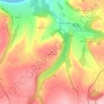
Name: Cefn Coed topographic map, elevation, terrain.
Location: Cefn Coed, Ceredigion, Wales, SA44 6NW, United Kingdom (52.19702 -4.33259 52.19712 -4.33249)
Average elevation: 381 ft
Minimum elevation: 0 ft
Maximum elevation: 627 ft
Other topographic maps
Click on a map to view its topography, its elevation and its terrain.
Beulah
United Kingdom > Wales > Ceredigion > Beulah
Beulah, Ceredigion, Wales, SA38 9QB, United Kingdom
Average elevation: 456 ft
Llanddewi Brefi
United Kingdom > Wales > Ceredigion > Llanddewi Brefi
Llanddewi Brefi, Ceredigion, Wales, SY25 6RS, United Kingdom
Average elevation: 791 ft
Llyn Fanod
United Kingdom > Wales > Ceredigion
Llyn Fanod, Llangeitho, Ceredigion, Wales, United Kingdom
Average elevation: 984 ft