
Jamtalferner topographic map
Interactive map
Click on the map to display elevation.
About this map
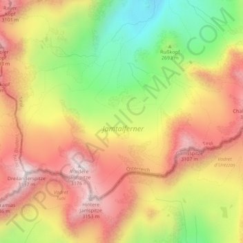
Name: Jamtalferner topographic map, elevation, terrain.
Average elevation: 9,173 ft
Minimum elevation: 7,818 ft
Maximum elevation: 10,312 ft
Other topographic maps
Click on a map to view its topography, its elevation and its terrain.
Zeinisjoch
Österreich > Vorarlberg > Galtür
Zeinisjoch, , Soppen, Galtür, Bludenz, Vorarlberg, 6563, Österreich
Average elevation: 6,765 ft