
Barkel topographic map
Interactive map
Click on the map to display elevation.
About this map
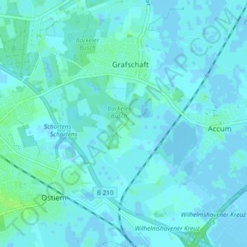
Name: Barkel topographic map, elevation, terrain.
Average elevation: 7 ft
Minimum elevation: -20 ft
Maximum elevation: 30 ft
Other topographic maps
Click on a map to view its topography, its elevation and its terrain.
Moorsum
Deutschland > Niedersachsen > Landkreis Friesland > Schortens
Moorsum, Schortens, Wangerland, Landkreis Friesland, Niedersachsen, 26419, Deutschland
Average elevation: 3 ft
Sillenstede
Deutschland > Niedersachsen > Landkreis Friesland > Schortens
Sillenstede, Schortens, Wangerland, Landkreis Friesland, Niedersachsen, 26419, Deutschland
Average elevation: 3 ft