
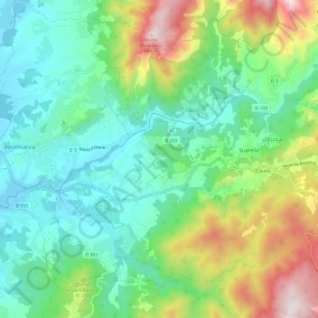
Eccica-Suarella topographic map
Interactive map
Click on the map to display elevation.
About this map
Name: Eccica-Suarella topographic map, elevation, terrain.
Average elevation: 863 ft
Minimum elevation: 3 ft
Maximum elevation: 2,920 ft
Other topographic maps
Click on a map to view its topography, its elevation and its terrain.
Catarelli
France > Corse > Corse-du-Sud > Eccica-Suarella > Suarella
Catarelli, Suarella, Eccica-Suarella, Ajaccio, Corse-du-Sud, Corse, France métropolitaine, 20117, France
Average elevation: 833 ft
San-Gavino-di-Carbini
France > Corse > Corse-du-Sud
San-Gavino-di-Carbini, Sartène, Corse-du-Sud, Corse, France métropolitaine, 20170, France
Average elevation: 2,119 ft
Urbalacone
France > Corse > Corse-du-Sud
Urbalacone, Ajaccio, Corse-du-Sud, Corse, France métropolitaine, 20128, France
Average elevation: 1,099 ft