
Fox Field topographic map
Interactive map
Click on the map to display elevation.
About this map
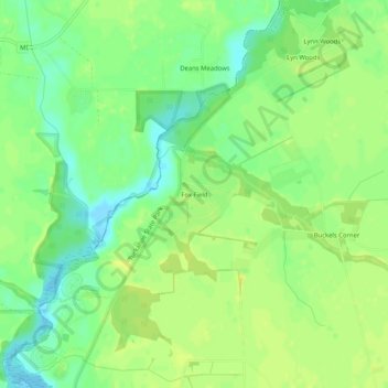
Name: Fox Field topographic map, elevation, terrain.
Location: Fox Field, Caroline County, Maryland, 21641, United States (38.97400 -75.93549 39.01400 -75.89549)
Average elevation: 49 ft
Minimum elevation: 13 ft
Maximum elevation: 72 ft
Other topographic maps
Click on a map to view its topography, its elevation and its terrain.
Ridgely
United States > Maryland > Caroline County
Ridgely, Caroline County, Maryland, 21660, United States
Average elevation: 59 ft