
Make a donation
Gear up for your next adventure:
As an Amazon Associate, this site earns from qualifying purchases at no extra cost to you.
Kvilda topographic map
Click on the map to display elevation.
Make a donation
Gear up for your next adventure:
As an Amazon Associate, this site earns from qualifying purchases at no extra cost to you.
Kvilda
Kvilda (German: Außergefild) is a village in Prachatice District, South Bohemian Region, Czech Republic. It lies in Šumava region, in the elevation of 1,065 m, making it the highest-located municipality in the country. It is also the coldest place in the Czech Republic with average annual temperature of 2 °C (36 °F). The average number of below-zero days per annum is 252.
Make a donation
Gear up for your next adventure:
As an Amazon Associate, this site earns from qualifying purchases at no extra cost to you.
About this map
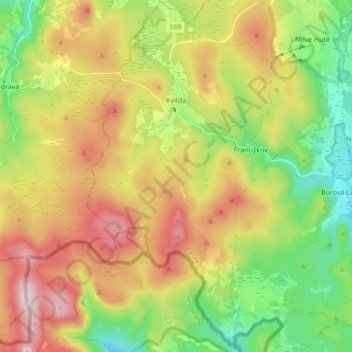
Name: Kvilda topographic map, elevation, terrain.
Average elevation: 3,593 ft
Minimum elevation: 2,894 ft
Maximum elevation: 4,514 ft
Make a donation
Gear up for your next adventure:
As an Amazon Associate, this site earns from qualifying purchases at no extra cost to you.