Geolocate

Derby topographic map

Click on the map to display elevation.

About this map

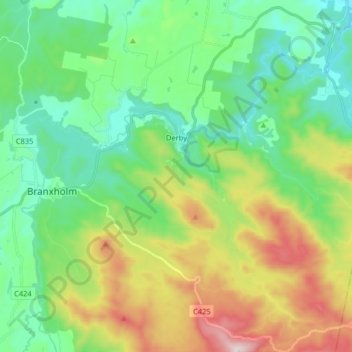
Name: Derby topographic map, elevation, terrain.

Location: Derby, Dorset, Tasmania, Australia (-41.22327 147.76642 -41.10153 147.88953)

Average elevation: 1,050 ft

Minimum elevation: 328 ft

Maximum elevation: 2,657 ft

Other topographic maps

Click on a map to view its topography, its elevation and its terrain.

Cathedral Mountain

Australia > Tasmania

Average elevation: 3,255 ft

Waterworks Reserve

Australia > Tasmania > Hobart

Average elevation: 787 ft

Rowlands Hill

Australia > Tasmania

Average elevation: 1,273 ft

Cradle Mountain

Australia > Tasmania > Cradle Mountain

Average elevation: 3,753 ft

The Nut

Australia > Tasmania > Stanley

Average elevation: 26 ft

Bream Creek

Australia > Tasmania > Bream Creek

Average elevation: 115 ft

Buxton Point

Australia > Tasmania > Little Swanport

Average elevation: 10 ft

Mount Patrick

Australia > Tasmania

Average elevation: 2,831 ft

Mount Ossa

Australia > Tasmania

Average elevation: 3,996 ft

West Gawler River

Australia > Tasmania > Sprent > Gawler

Average elevation: 659 ft

Mount Tyndall

Australia > Tasmania

Average elevation: 2,986 ft

Gear up for your next adventure:

🏫Relief Map Kits - Hands-on tools for teaching landforms and elevation
📱Heavy-Duty Phone Cases - Drop-proof and waterproof protection for outdoor navigation
⛑️Personal Locator Beacon - Safety beacon for emergencies
🧭Compass with Lanyard - Easy‑carry compass for navigation
🥩Freeze-Dried Meals - Nutritious and lightweight food for remote expeditions

As an Amazon Associate, this site earns from qualifying purchases at no extra cost to you.