
Make a donation
Gear up for your next adventure:
As an Amazon Associate, this site earns from qualifying purchases at no extra cost to you.
Huemul Island topographic map
Click on the map to display elevation.
Make a donation
Gear up for your next adventure:
As an Amazon Associate, this site earns from qualifying purchases at no extra cost to you.
About this map
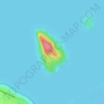
Name: Huemul Island topographic map, elevation, terrain.
Average elevation: 2,539 ft
Minimum elevation: 2,516 ft
Maximum elevation: 2,894 ft
Make a donation
Gear up for your next adventure:
As an Amazon Associate, this site earns from qualifying purchases at no extra cost to you.
Other topographic maps
Click on a map to view its topography, its elevation and its terrain.
Make a donation
Gear up for your next adventure:
As an Amazon Associate, this site earns from qualifying purchases at no extra cost to you.
Make a donation
Gear up for your next adventure:
As an Amazon Associate, this site earns from qualifying purchases at no extra cost to you.
Make a donation
Gear up for your next adventure:
As an Amazon Associate, this site earns from qualifying purchases at no extra cost to you.
San Carlos de Bariloche
Argentina > Río Negro Province
Bariloche lies in the transition between a cool Mediterranean climate (Köppen Csb) and an Oceanic climate (Köppen: Cfb), with marked alpine characteristics (low nighttime temperatures, wide temperature variations, high thermal amplitude). The combination of its altitude, latitude, and predominance of…
Average elevation: 3,419 ft
Make a donation
Gear up for your next adventure:
As an Amazon Associate, this site earns from qualifying purchases at no extra cost to you.
Municipio de Cipolletti
Argentina > Río Negro Province > Municipio de Cipolletti
Average elevation: 1,522 ft
Make a donation
Gear up for your next adventure:
As an Amazon Associate, this site earns from qualifying purchases at no extra cost to you.