
希夏邦马峰 topographic map
Interactive map
Click on the map to display elevation.
About this map
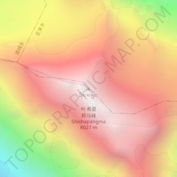
Name: 希夏邦马峰 topographic map, elevation, terrain.
Location: 希夏邦马峰, 聂拉木镇, 聂拉木县, 日喀则市, 西藏自治区, 中国 (28.35532 85.77823 28.35542 85.77833)
Average elevation: 23,727 ft
Minimum elevation: 19,245 ft
Maximum elevation: 26,266 ft
希夏邦马峰(藏語:ཤིས་ས་སྤང་མ།,威利转写:shis sa spang ma,藏语拼音:Xisabangma,意为“气候严酷”,旧称「高僧赞峰」)位于西藏自治区日喀則市聂拉木县境内,海拔8,027米,是世界上14座8,000米级高峰中的最低一位,也是唯一的一座完全在中国境内的8,000米级山峰。
Other topographic maps
Click on a map to view its topography, its elevation and its terrain.