
Vila Nova de Gaia topographic map
Interactive map
Click on the map to display elevation.
About this map
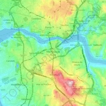
Name: Vila Nova de Gaia topographic map, elevation, terrain.
Average elevation: 279 ft
Minimum elevation: -3 ft
Maximum elevation: 1,699 ft
Other topographic maps
Click on a map to view its topography, its elevation and its terrain.
Devesas
Portugal > Porto > Vila Nova de Gaia
Devesas, Santa Marinha e São Pedro da Afurada, Vila Nova de Gaia, Porto, 4400-092, Portugal
Average elevation: 266 ft
Lever
Portugal > Porto > Vila Nova de Gaia
Lever, Vila Nova de Gaia, Porto, 4415-638, Portugal
Average elevation: 351 ft
Serzedo
Portugal > Porto > Vila Nova de Gaia
Serzedo, Vila Nova de Gaia, Porto, 4405-463, Portugal
Average elevation: 285 ft