
Community of Ano Trikala topographic map
Interactive map
Click on the map to display elevation.
About this map
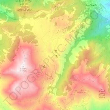
Name: Community of Ano Trikala topographic map, elevation, terrain.
Average elevation: 5,089 ft
Minimum elevation: 1,821 ft
Maximum elevation: 7,766 ft
Other topographic maps
Click on a map to view its topography, its elevation and its terrain.
Kyllini (Ziria)
Greece > Peloponnese, Western Greece and the Ionian > Corinthia Regional Unit > Municipal Unit of Xylokastro
Kyllini (Ziria), Municipal Unit of Xylokastro, Municipality of Xylokastro and Evrostina, Corinthia Regional Unit, Peloponnese Region, Peloponnese, Western Greece and the Ionian, Greece
Average elevation: 6,542 ft