
Kannaland Ward 4 topographic map
Interactive map
Click on the map to display elevation.
About this map
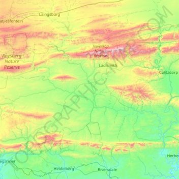
Name: Kannaland Ward 4 topographic map, elevation, terrain.
Average elevation: 1,919 ft
Minimum elevation: 39 ft
Maximum elevation: 7,566 ft
Other topographic maps
Click on a map to view its topography, its elevation and its terrain.
Van Wyksdorp
South Africa > Western Cape > Garden Route District Municipality > Kannaland Local Municipality
Van Wyksdorp, Kannaland Local Municipality, Garden Route District Municipality, Western Cape, South Africa
Average elevation: 823 ft
Ladismith
South Africa > Western Cape > Garden Route District Municipality > Kannaland Local Municipality
Ladismith, Kannaland Local Municipality, Garden Route District Municipality, Western Cape, South Africa
Average elevation: 1,985 ft