
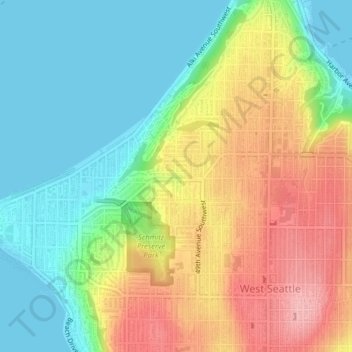
Nantes Park topographic map
Interactive map
Click on the map to display elevation.
About this map
Name: Nantes Park topographic map, elevation, terrain.
Average elevation: 174 ft
Minimum elevation: -3 ft
Maximum elevation: 430 ft
Other topographic maps
Click on a map to view its topography, its elevation and its terrain.
Queen Anne Hill
United States > Washington > King County > Seattle
Queen Anne Hill, Seattle, King County, Washington, 98109, United States
Average elevation: 180 ft
High Point
United States > Washington > King County > Seattle
High Point, Seattle, King County, Washington, 98126, United States
Average elevation: 289 ft
Licton Springs
United States > Washington > King County > Seattle
Licton Springs, Ashworth Avenue North, Licton Springs, Greenwood, Seattle, King County, Washington, 98113, United States
Average elevation: 315 ft
Lemur
United States > Washington > King County > Seattle
Lemur, Phinney Ridge, Seattle, King County, Washington, United States
Average elevation: 194 ft
Arbor Heights
United States > Washington > King County > Seattle > Arbor Heights
Arbor Heights, Seattle, King County, Washington, 98146, United States
Average elevation: 197 ft
Bitter Lake
United States > Washington > King County > Seattle > Bitter Lake
Bitter Lake, Seattle, King County, Washington, 98133, United States
Average elevation: 367 ft