
Pharaoh's Island topographic map
Interactive map
Click on the map to display elevation.
About this map
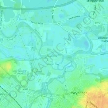
Name: Pharaoh's Island topographic map, elevation, terrain.
Average elevation: 46 ft
Minimum elevation: 23 ft
Maximum elevation: 118 ft
Other topographic maps
Click on a map to view its topography, its elevation and its terrain.
Charlton
United Kingdom > England > Surrey > Borough of Spelthorne
Charlton, Borough of Spelthorne, Surrey, England, TW17 0ST, United Kingdom
Average elevation: 43 ft
Laleham
United Kingdom > England > Surrey > Borough of Spelthorne
Laleham, Borough of Spelthorne, Surrey, England, TW18 1SD, United Kingdom
Average elevation: 46 ft
Upper Halliford
United Kingdom > England > Surrey > Borough of Spelthorne
Upper Halliford, Borough of Spelthorne, Surrey, England, TW17 8SQ, United Kingdom
Average elevation: 43 ft
Shepperton
United Kingdom > England > Surrey > Borough of Spelthorne
Shepperton, Borough of Spelthorne, Surrey, England, United Kingdom
Average elevation: 39 ft
Ashford
United Kingdom > England > Surrey > Borough of Spelthorne
Ashford, Borough of Spelthorne, Surrey, England, United Kingdom
Average elevation: 52 ft
Stanwell
United Kingdom > England > Surrey > Borough of Spelthorne
Stanwell, Borough of Spelthorne, Surrey, England, TW19 7EB, United Kingdom
Average elevation: 66 ft