
Umtamvuna Nature Reserve topographic map
Interactive map
Click on the map to display elevation.
About this map
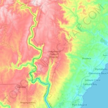
Name: Umtamvuna Nature Reserve topographic map, elevation, terrain.
Average elevation: 814 ft
Minimum elevation: 0 ft
Maximum elevation: 1,667 ft
Other topographic maps
Click on a map to view its topography, its elevation and its terrain.
Shelly Beach
South Africa > KwaZulu-Natal > Ugu District Municipality > Hibiscus Coast Local Municipality
Shelly Beach, Hibiscus Coast Local Municipality, Ugu District Municipality, KwaZulu-Natal, 4265, South Africa
Average elevation: 82 ft
Black Rock
South Africa > KwaZulu-Natal > Ugu District Municipality > Hibiscus Coast Local Municipality > Port Edward
Black Rock, Hibiscus Coast Ward 1, Port Edward, Hibiscus Coast Local Municipality, Ugu District Municipality, KwaZulu-Natal, 4295, South Africa
Average elevation: 66 ft
Ivy Beach
South Africa > KwaZulu-Natal > Ugu District Municipality > Hibiscus Coast Local Municipality > Leisure Bay
Ivy Beach, Hibiscus Coast Ward 1, Leisure Bay, Hibiscus Coast Local Municipality, Ugu District Municipality, KwaZulu-Natal, 4278, South Africa
Average elevation: 102 ft
Margate Beach
South Africa > KwaZulu-Natal > Ugu District Municipality > Hibiscus Coast Local Municipality > Margate
Margate Beach, Hibiscus Coast Ward 2, Margate, Hibiscus Coast Local Municipality, Ugu District Municipality, KwaZulu-Natal, 4270, South Africa
Average elevation: 102 ft
Port Shepstone
South Africa > KwaZulu-Natal > Ugu District Municipality > Hibiscus Coast Local Municipality
Port Shepstone, Hibiscus Coast Local Municipality, Ugu District Municipality, KwaZulu-Natal, 4680, South Africa
Average elevation: 108 ft
Port Edward
South Africa > KwaZulu-Natal > Ugu District Municipality > Hibiscus Coast Local Municipality
Port Edward, Hibiscus Coast Local Municipality, Ugu District Municipality, KwaZulu-Natal, 4295, South Africa
Average elevation: 138 ft
Anerley
South Africa > KwaZulu-Natal > Ugu District Municipality > Hibiscus Coast Local Municipality
Anerley, Hibiscus Coast Local Municipality, Ugu District Municipality, KwaZulu-Natal, 4230, South Africa
Average elevation: 82 ft
Glenmore Beach
South Africa > KwaZulu-Natal > Ugu District Municipality > Hibiscus Coast Local Municipality > Glenmore Beach
Glenmore Beach, Hibiscus Coast Local Municipality, Ugu District Municipality, KwaZulu-Natal, 4278, South Africa
Average elevation: 125 ft
Ramsgate
South Africa > KwaZulu-Natal > Ugu District Municipality > Hibiscus Coast Local Municipality
Ramsgate, Hibiscus Coast Local Municipality, Ugu District Municipality, KwaZulu-Natal, South Africa
Average elevation: 95 ft
Margate
South Africa > KwaZulu-Natal > Ugu District Municipality > Hibiscus Coast Local Municipality
Margate, Hibiscus Coast Local Municipality, Ugu District Municipality, KwaZulu-Natal, 4270, South Africa
Average elevation: 148 ft
Portobello
South Africa > KwaZulu-Natal > Ugu District Municipality > Hibiscus Coast Local Municipality > Portobello
Portobello, Hibiscus Coast Local Municipality, Ugu District Municipality, KwaZulu-Natal, 4278, South Africa
Average elevation: 121 ft