
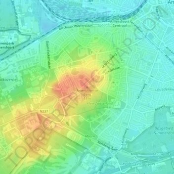
Amersfoortse Berg topographic map
Interactive map
Click on the map to display elevation.
About this map
Name: Amersfoortse Berg topographic map, elevation, terrain.
Average elevation: 62 ft
Minimum elevation: 10 ft
Maximum elevation: 157 ft
De zuidwestelijke Amersfoortse wijk Bergkwartier is naar de heuvel vernoemd. Het parkachtige bos op de Amersfoortse Berg wordt Klein Zwitserland genoemd vanwege de voor Nederland vrij grote hoogteverschillen.
Other topographic maps
Click on a map to view its topography, its elevation and its terrain.
Hoogland
Nederland > Utrecht > Amersfoort > Hoogland
Hoogland, Amersfoort, Utrecht, Nederland
Average elevation: 7 ft