
Santa Susanna topographic map
Interactive map
Click on the map to display elevation.
About this map
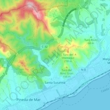
Name: Santa Susanna topographic map, elevation, terrain.
Location: Santa Susanna, Maresme, Barcelona, Catalonië, 08398, Spanje (41.62501 2.65836 41.67239 2.72762)
Average elevation: 246 ft
Minimum elevation: -3 ft
Maximum elevation: 1,086 ft
Other topographic maps
Click on a map to view its topography, its elevation and its terrain.
Malgrat de Mar
Spanje > Catalonië > Maresme > Malgrat de Mar > Malgrat de Mar
Malgrat de Mar, Maresme, Barcelona, Catalonië, 08380, Spanje
Average elevation: 66 ft