
Coniston topographic map
Interactive map
Click on the map to display elevation.
About this map
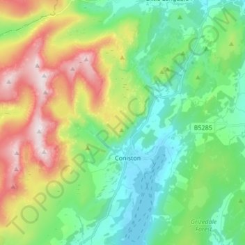
Name: Coniston topographic map, elevation, terrain.
Location: Coniston, South Lakeland, Cumbria, England, United Kingdom (54.34057 -3.13139 54.41945 -3.02986)
Average elevation: 925 ft
Minimum elevation: 148 ft
Maximum elevation: 2,612 ft
Other topographic maps
Click on a map to view its topography, its elevation and its terrain.
Windermere
United Kingdom > England > Cumbria > South Lakeland
Windermere, South Lakeland, Cumbria, England, LA23 1AB, United Kingdom
Average elevation: 482 ft