
Make a donation
Gear up for your next adventure:
As an Amazon Associate, this site earns from qualifying purchases at no extra cost to you.
Wetterfeld topographic map
Click on the map to display elevation.
Make a donation
Gear up for your next adventure:
As an Amazon Associate, this site earns from qualifying purchases at no extra cost to you.
About this map
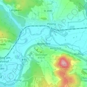
Name: Wetterfeld topographic map, elevation, terrain.
Location: Wetterfeld, Roding, Landkreis Cham, Bayern, 93483, Deutschland (49.20095 12.52367 49.24095 12.56367)
Average elevation: 1,273 ft
Minimum elevation: 1,158 ft
Maximum elevation: 1,690 ft
Make a donation
Gear up for your next adventure:
As an Amazon Associate, this site earns from qualifying purchases at no extra cost to you.
Other topographic maps
Click on a map to view its topography, its elevation and its terrain.
Burgruine Schwärzenburg
Deutschland > Bayern > Landkreis Cham > Roding > Strahlfeld
Die Höhenburg wurde vermutlich im 13. Jahrhundert auf dem Grund des Bamberger Bischofs von den Herren von Fronau (Adelsgeschlecht), die schon Anfang des 12. Jahrhunderts urkundlich genannt wurden, erbaut. Eine Vorgängeranlage der Höhenburg könnte die Turmhügelburg Haselberg auf dem Gebiet des Haselbergs…
Average elevation: 1,493 ft