
Make a donation
Gear up for your next adventure:
As an Amazon Associate, this site earns from qualifying purchases at no extra cost to you.
Amberley topographic map
Click on the map to display elevation.
Make a donation
Gear up for your next adventure:
As an Amazon Associate, this site earns from qualifying purchases at no extra cost to you.
About this map
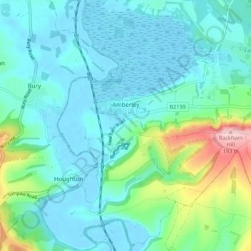
Name: Amberley topographic map, elevation, terrain.
Location: Amberley, Horsham, West Sussex, England, United Kingdom (50.88008 -0.56107 50.92935 -0.49994)
Average elevation: 121 ft
Minimum elevation: -10 ft
Maximum elevation: 630 ft
Make a donation
Gear up for your next adventure:
As an Amazon Associate, this site earns from qualifying purchases at no extra cost to you.
Other topographic maps
Click on a map to view its topography, its elevation and its terrain.
Smock Alley
United Kingdom > England > West Sussex > Horsham > West Chiltington
Average elevation: 125 ft
Wickhurst Green
United Kingdom > England > West Sussex > Horsham > Wickhurst Green
Average elevation: 148 ft
Make a donation
Gear up for your next adventure:
As an Amazon Associate, this site earns from qualifying purchases at no extra cost to you.