
Toledo topographic map
Interactive map
Click on the map to display elevation.
About this map
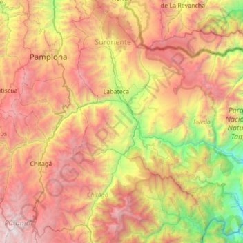
Name: Toledo topographic map, elevation, terrain.
Location: Toledo, Suroriente, Norte de Santander, Colombie (6.97673 -72.59578 7.48647 -72.04758)
Average elevation: 7,766 ft
Minimum elevation: 1,594 ft
Maximum elevation: 14,885 ft
Other topographic maps
Click on a map to view its topography, its elevation and its terrain.
Pamplona
Pamplona, Suroccidente, Norte de Santander, RAP Gran Santander, Colombie
Average elevation: 8,438 ft
Tibú
Tibú, Norte, Norte de Santander, Colombie
Average elevation: 1,516 ft
San Calixto
San Calixto, Occidente, Norte de Santander, Colombie
Average elevation: 1,988 ft
Catatumbo
Colombie > Norte de Santander > Tibú
Catatumbo, Tibú, Norte, Norte de Santander, Colombie
Average elevation: 358 ft
Tibú
Colombie > Norte de Santander > Tibú > Tibú
Tibú, Norte, Norte de Santander, Colombie
Average elevation: 200 ft
Villa del Rosario
Villa del Rosario, Oriental, Norte de Santander, 541030, Colombie
Average elevation: 2,759 ft
Catatumbo
Catatumbo, Corregimiento Orú, El Tarra, Norte de Santander, Colombie
Average elevation: 387 ft
Convención
Convención, Norte de Santander, Colombie
Average elevation: 1,893 ft
Tibú
Tibú, Norte, Norte de Santander, Región Andina, Colombie
Average elevation: 1,444 ft
La Gabarra
Colombie > Norte de Santander > La Gabarra
La Gabarra, Tibú, Norte de Santander, Colombie
Average elevation: 325 ft