
Centro topographic map
Click on the map to display elevation.
About this map
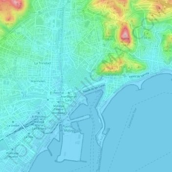
Name: Centro topographic map, elevation, terrain.
Location: Centro, Málaga, Málaga-Costa del Sol, Malaga, Andalusia, Spain (36.69871 -4.43268 36.73976 -4.39728)
Average elevation: 85 ft
Minimum elevation: -7 ft
Maximum elevation: 604 ft
Other topographic maps
Click on a map to view its topography, its elevation and its terrain.
Málaga
Spain > Andalusia > Málaga-Costa del Sol > Málaga
Like many of the military fortifications that were constructed in Islamic Spain, the Alcazaba of Málaga featured a quadrangular plan. It was protected by an outer and inner wall, both supported by rectangular towers, between which a covered walkway led up the slope to the Gibralfaro (this was the only…
Average elevation: 705 ft