
Middlesborough topographic map
Interactive map
Click on the map to display elevation.
About this map
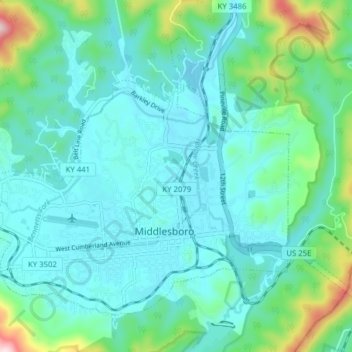
Name: Middlesborough topographic map, elevation, terrain.
Location: Middlesborough, Bell County, Kentucky, United States (36.59332 -83.76681 36.64296 -83.68887)
Average elevation: 1,332 ft
Minimum elevation: 1,099 ft
Maximum elevation: 2,490 ft
Other topographic maps
Click on a map to view its topography, its elevation and its terrain.
Fourmile
United States > Kentucky > Bell County
Fourmile, Bell County, Kentucky, 40939, United States
Average elevation: 1,332 ft
Arjay
United States > Kentucky > Bell County
Arjay, Bell County, Kentucky, 40902, United States
Average elevation: 1,522 ft
Stoney Fork
United States > Kentucky > Bell County
Stoney Fork, Bell County, Kentucky, United States
Average elevation: 1,703 ft
Beverly
United States > Kentucky > Bell County
Beverly, Bell County, Kentucky, 40913, United States
Average elevation: 1,726 ft
Calvin
United States > Kentucky > Bell County
Calvin, Bell County, Kentucky, 40813, United States
Average elevation: 1,296 ft
Kettle Island
United States > Kentucky > Bell County
Kettle Island, Bell County, Kentucky, 40988, United States
Average elevation: 1,539 ft
Miracle
United States > Kentucky > Bell County
Miracle, Bell County, Kentucky, 40988, United States
Average elevation: 1,355 ft
Pineville
United States > Kentucky > Bell County
Pineville, Bell County, Kentucky, United States
Average elevation: 1,398 ft