
Make a donation
Gear up for your next adventure:
As an Amazon Associate, this site earns from qualifying purchases at no extra cost to you.
Calvin topographic map
Click on the map to display elevation.
Make a donation
Gear up for your next adventure:
As an Amazon Associate, this site earns from qualifying purchases at no extra cost to you.
About this map
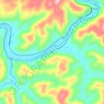
Name: Calvin topographic map, elevation, terrain.
Location: Calvin, Bell County, Kentucky, 40813, United States (36.70231 -83.64214 36.74231 -83.60214)
Average elevation: 1,296 ft
Minimum elevation: 997 ft
Maximum elevation: 1,781 ft
Bell County trails, hiking, mountain biking, running and outdoor activities
Make a donation
Gear up for your next adventure:
As an Amazon Associate, this site earns from qualifying purchases at no extra cost to you.
Other topographic maps
Click on a map to view its topography, its elevation and its terrain.
Pine Mountain State Resort Park
United States > Kentucky > Bell County > Pineville
Average elevation: 1,604 ft