
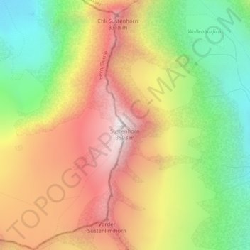
Sustenhorn topographic map
Interactive map
Click on the map to display elevation.
About this map
Name: Sustenhorn topographic map, elevation, terrain.
Location: Sustenhorn, Göschenen, Uri, 6487, Suisse (46.69887 8.45515 46.69897 8.45525)
Average elevation: 9,373 ft
Minimum elevation: 7,356 ft
Maximum elevation: 11,417 ft
Le Sustenhorn est un sommet des Alpes uranaises, en Suisse. Il culmine à 3 502 m d'altitude.
Other topographic maps
Click on a map to view its topography, its elevation and its terrain.