Geolocate

Brevard topographic map

Click on the map to display elevation.

About this map

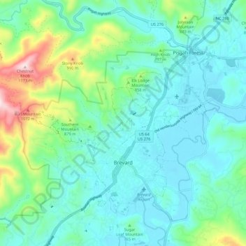
Name: Brevard topographic map, elevation, terrain.

Location: Brevard, Transylvania County, North Carolina, United States (35.20933 -82.79070 35.28541 -82.68419)

Average elevation: 2,444 ft

Minimum elevation: 2,077 ft

Maximum elevation: 3,829 ft

Transylvania County trails, hiking, mountain biking, running and outdoor activities

Other topographic maps

Click on a map to view its topography, its elevation and its terrain.

Penrose

United States > North Carolina > Transylvania County

Average elevation: 2,287 ft

Sapphire

United States > North Carolina > Transylvania County

Average elevation: 3,271 ft

Sapphire

United States > North Carolina > Transylvania County

Average elevation: 3,271 ft

Penrose

United States > North Carolina > Transylvania County > Penrose

Average elevation: 2,287 ft

Gear up for your next adventure:

🚁Photography Drones - Capture stunning aerial views of landforms and topography
🪶Camp Gear Gift Set - Perfect gift bundle for outdoor fans
🛡️Bear Spray Outdoor - Protection in bear country hikes
🧥Men's Rain Shells - Premium waterproof and breathable jackets for mountain weather
🧤Tactile Hiking Gloves - Keep hands warm while operating GPS and smartphone screens

As an Amazon Associate, this site earns from qualifying purchases at no extra cost to you.