
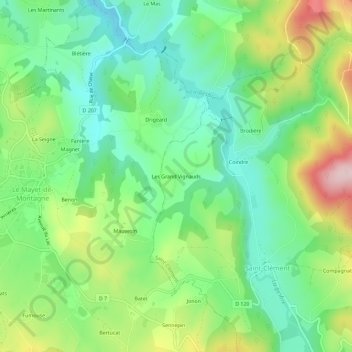
Les Grand Vignauds topographic map
Interactive map
Click on the map to display elevation.
About this map
Name: Les Grand Vignauds topographic map, elevation, terrain.
Average elevation: 1,791 ft
Minimum elevation: 1,463 ft
Maximum elevation: 2,405 ft
Other topographic maps
Click on a map to view its topography, its elevation and its terrain.
La Maison Neuve
France > Auvergne-Rhône-Alpes > Allier > Saint-Clément
La Maison Neuve, Saint-Clément, Vichy, Allier, Auvergne-Rhône-Alpes, France métropolitaine, 03250, France
Average elevation: 2,136 ft
La Jurie
France > Auvergne-Rhône-Alpes > Allier > Saint-Clément
La Jurie, Saint-Clément, Vichy, Allier, Auvergne-Rhône-Alpes, France métropolitaine, 03250, France
Average elevation: 2,093 ft
Rivière
France > Auvergne-Rhône-Alpes > Allier > Saint-Clément > Goulange
Rivière, Goulange, Saint-Clément, Vichy, Allier, Auvergne-Rhône-Alpes, France métropolitaine, 03250, France
Average elevation: 1,942 ft
Le Morin
France > Auvergne-Rhône-Alpes > Allier > Saint-Clément
Le Morin, Saint-Clément, Vichy, Allier, Auvergne-Rhône-Alpes, France métropolitaine, 03250, France
Average elevation: 2,287 ft